From Algiers to Lagos, from the Mediterranean to the Gulf of Guinea – this is 5,400 kilometers of beauty, adventure, danger, and challenge along the route connecting Africa’s largest and most populous countries
Many places and routes around the world are still considered hard to access or pose major challenges to those who decide to venture through them. These could be remote locations that are difficult to reach, harsh climates that only the toughest can endure, or inherently dangerous areas due to political instability. Today’s story involves all these elements, and the well-known saying that “the journey is more important than the destination” is truly fitting here.
We begin our journey on the northern coast of Africa, more precisely in Algiers, the capital (and main port) of Algeria. Starting in the geographically largest country in Africa (a title that once belonged to Sudan before it split into Sudan and South Sudan), our goal is to reach the continent’s most populous country, Nigeria (around 206 million people), specifically its largest port, Lagos. This journey takes us from the Mediterranean all the way to the Gulf of Guinea.
Of course, we could take a flight, which would likely be the smartest option. There’s no direct flight, meaning we’d first have to fly from Algiers to Paris and then transfer to Lagos. Another option is via Istanbul, but either way, it would take a good 12 hours. But for the bold, there’s another option: by road, straight through Africa – 4,500 kilometers of unpredictability. Naturally, this road is only for the brave and those who love taking risks. We, however, will “travel” it only through an exciting story.
The road is called the Trans-Saharan Highway. As mentioned, it is exactly 4,504 kilometers long and passes through three major countries. We travel through all of Algeria, then Niger, and finally all of Nigeria, down to the sea.
Right from the start, the fact that the highway passes through Niger sounds dangerous, as this is a region with increasing militant activity that has spread in recent years from Mali (and also Burkina Faso), and Nigeria itself is no stranger to such dangers. Algeria? Less so, but the long stretches of road, especially as we approach the southern part of the country and the border with Niger, can be hazardous.
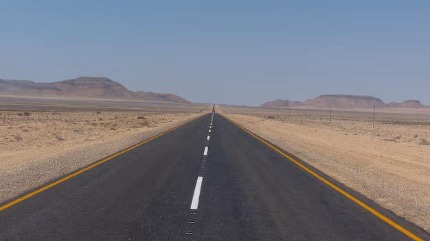
As for the road itself, recent estimates say it is about 85% paved, which would be good news – if that were a consistent figure. In some parts, desert sand completely covers the road, and only traces of vehicles that passed before you may remain visible. If even those are erased by wind-blown sand, you could find yourself in quite an unpleasant and uneasy situation.
Still, the world’s challenging roads have always attracted adventurers, and the Trans-Saharan Highway is no exception.
This route does not only directly connect Algiers and Lagos, although those are its endpoints. It has around 3,600 kilometers of branches leading toward Tunisia, Mali, Chad…
Not surprisingly, not all parts are the same. About half of the road lies within Algeria – over 2,300 kilometers – and the condition is relatively good, at least until you reach the southern city of Tamanrasset. After that, there are “only” about 400 kilometers left to the Niger border. Beyond Tamanrasset, conditions worsen rapidly – unsurprising, since it’s the last sizable city in Algeria when heading south. Tamanrasset has about 100,000 residents and is an ideal place to rest and stock up before the next leg of the adventure.
Only one more town remains before Niger: Guezzam, a much smaller settlement with around 7,000 people. Beyond Guezzam, there’s no more pavement. Algerian authorities claim they’ll pave that section within the year, but whether they will remains to be seen.
Guezzam is the last place to rest, although if you can’t stand heat, you probably won’t enjoy it too much. In summer, temperatures often exceed 40°C (104°F), and even in winter they easily reach 30°C (86°F). We are in a hot desert climate, but if you’ve made it this far, you’re surely used to it, as all of Algeria and Niger “bake” in the same heat… only upon entering Nigeria will you feel a major change.
985 kilometers of the highway pass through Niger. Officially, 785 of them are paved, but those who have traveled the route claim it is in “poor condition.”
By the time you’ve driven from the Mediterranean to the Niger border, you will have experienced all the beauty of the Sahara, which likely tested your endurance (and your vehicle’s) more than once. It goes without saying: this is not a road for your city car. A rugged, durable off-road vehicle is essential, and in case of a breakdown, it’s best if you know how to fix it quickly, because relying on roadside assistance in the Sahara is not a smart idea. And obviously, carrying water supplies is crucial, as places to restock will be rare.
Reaching the Niger border, you must first hope it’s even open. Due to militant activity and other security concerns, Algeria often closes (especially to foreigners) its southern border with Niger. But if you’ve made it here, it’s likely open – meaning you’ve previously gone through all the bureaucratic steps and received the necessary permits to even get this far, let alone cross the border.
It’s hard to say what might prevent you from continuing – the road or life itself. Daytime temperatures can hit 50°C (122°F), sandstorms can be so fierce that driving becomes impossible, and as a foreigner in a good vehicle, you may become a target for militant groups (who often operate near border zones).
As you pass through Niger, you’ll go by the city of Arlit, an industrial hub home to one of the largest uranium mines in the world. About 250 kilometers later, you’ll reach Agadez, a city of around 100,000 residents whose center is on the UNESCO World Heritage list.
Even larger is the next city, Zinder (the third largest in the country). If you’ve reached here, you’ve nearly completed the second leg of the journey. Niger and the Sahara are behind you, and about 100 kilometers south of Zinder begins the final stretch – Nigeria.
From the hot Saharan climate, you now enter a dense tropical zone with alternating wet and dry seasons. The first major city you’ll encounter is Kano. You haven’t seen a city this size since Algiers – Kano has more people than the entire country of Croatia, with over 4 million residents (it’s Nigeria’s second-largest city after our final destination, Lagos). Historically, it’s an important trade center.
Upon arriving in Kano, we left the eternal Sahel and entered the savanna… Temperatures are somewhat lower (though not by much), but the real question is how you handle the high humidity, which is common here.
On the way to Lagos, we’ll pass through the cities of Kaduna (formerly the capital of the once autonomous region of Northern Nigeria), Oyo (a city of about half a million people that’s definitely worth a stop—this is an ancient city, the center of the once-powerful Oyo Empire, which existed in West Africa from the mid-17th to the late 18th century), and then Ibadan (we’re almost at the coast now, and Ibadan is the third-largest city in Nigeria, with around 3.6 million inhabitants).
After Ibadan, we have only about 120 kilometers left before we reach Lagos, the largest city in Nigeria (though not the capital—that title belongs to Abuja). Lagos is, by all accounts and everything we’ve seen so far, perhaps even ever, a true urban giant with over 15 million people in the city proper, and if we include the metropolitan area (that is, suburban settlements connected to the city), the number climbs to over 25 million.
Lagos is by far the largest city in Nigeria and the second-largest in all of Africa (that position still officially belongs to Kinshasa, the capital of the Democratic Republic of Congo, but the difference is only about 300,000 people).
You’ve probably heard that Lagos is considered the “most dangerous city in Africa,” maybe even in the world. But if you managed to travel by road from Algeria to Lagos, you’re probably someone who handles danger quite well. So, is Lagos really that dangerous? Opinions are divided. The fact is, even by African standards, this is a very poor city, with almost half the population still living in slums. At the same time, Lagos is also the economic center of vast Nigeria.
For foreigners, Lagos poses a fairly high risk, particularly in terms of theft and similar attacks. There is no significant threat of terrorism here (unlike other parts of Nigeria), but there are other dangers. However, the situation is generally improving, and the city is no longer as dangerous as it once was, thanks largely to measures taken by city authorities. There is now much more police presence on the streets than, say, 10 years ago. In addition, many surveillance camerasare being installed to reduce crime. Understandably, going out alone in Lagos at night is very dangerous, but during the day, the biggest threats are likely to be scams and tricks targeting tourists and foreigners (especially those who obviously look like tourists!). That said, local residents are generally very friendly.
Lagos is a gigantic city where you’ll see everything—from severe poverty and people living in inhumane conditionsto luxury skyscrapers, attractive beaches, parks, and all other urban amenities.
But behind you lies the greatest adventure: the Trans-Saharan Highway, a challenge from start to finish. It’s not the longest (that would be the one from Cairo to Cape Town—over 10,000 kilometers!), but it is certainly the most difficult and most risky. The idea for the Trans-Saharan Highway was proposed in the 1960s, construction began in the 1970s, and even today it’s not fully completed, as some sections remain unpaved. Maybe one day it will become a modern highway throughout its entire stretch, like those we drive on in Europe—almost certainly it will reach that state eventually—but in the meantime, it remains a road only for true adventurers who want close contact with Africa, with the Sahara, to travel from sea to sea, and see both the roughest and most beautiful that the Black Continent has to offer.


